How we know
How we know the Apollo landings happened
Orbital cameras, hardware on the surface, lunar laser ranging, and public NASA archives each point to the same six landing zones. They are independent checks—no single photograph or document carries the full weight.
6
Landed Apollo sites
3
Apollo laser arrays
50+ yr
LLR program
Overview
Science rarely rests on a single photograph or a single witness. What matters is convergence: different instruments, different teams, and different eras pointing to the same physical reality.
For the Moon landings, that reality includes hardware at published coordinates, retroreflectors that still return laser pulses, and public archives detailed enough to reconstruct what happened on each flight.
This page sketches how those pieces fit together. For catalogued artefacts and direct links to data products, use the Evidence catalogue; for coordinates and regional context, open Explore; for flight-by-flight narrative and sources, use the mission dossiers.
“The strongest claims are the ones anyone can, in principle, re-check.”
Line of evidence
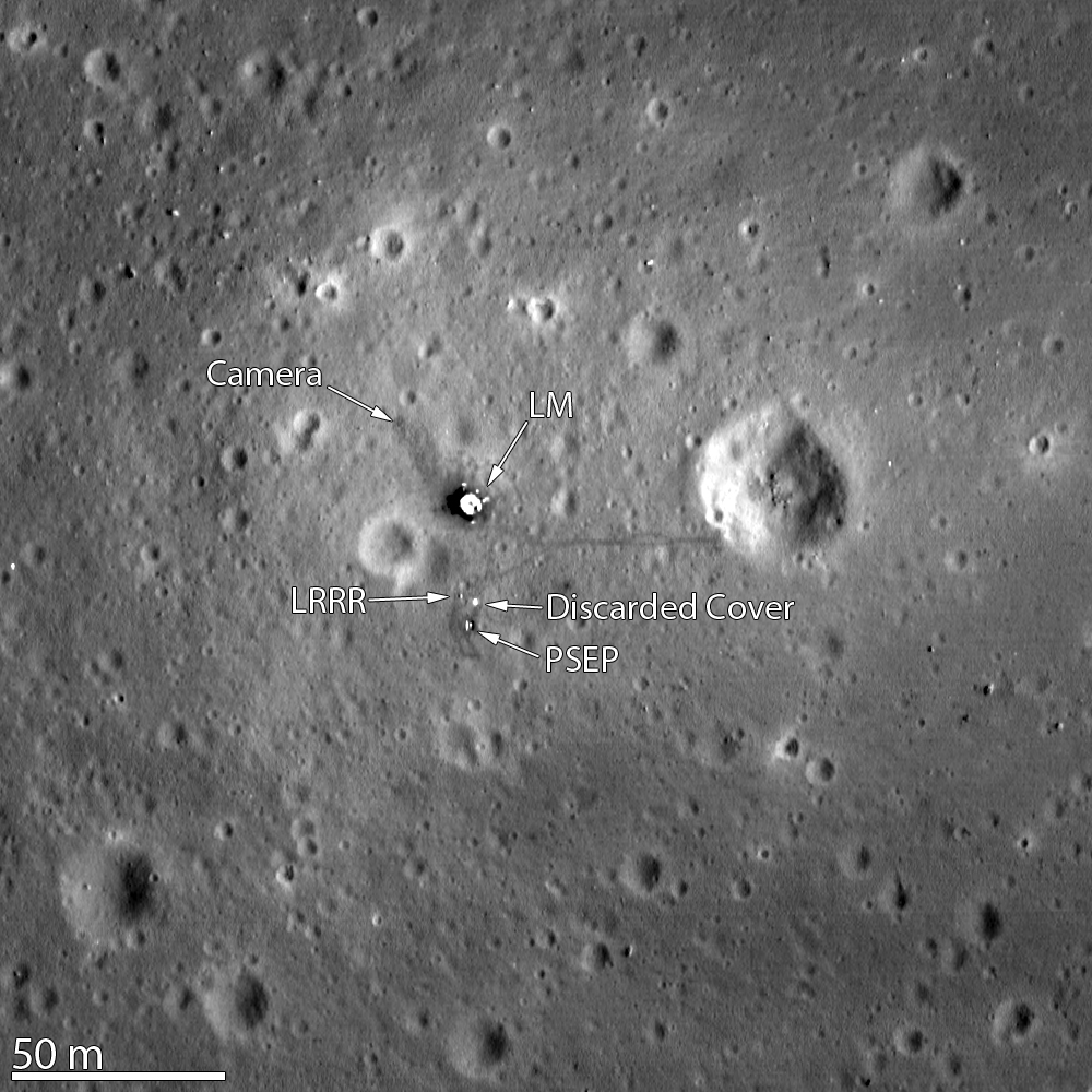
LRO and LROC images of each Apollo landing site
After Apollo, robotic orbiters mapped the Moon with narrow-angle cameras. Published LROC strips and mosaics cover every crewed landing zone at scales that resolve hardware and surface disturbance.
The Lunar Reconnaissance Orbiter Camera (LROC) and earlier missions mapped the Moon after Apollo. Published strips and mosaics cover Tranquility Base, the Ocean of Storms, Fra Mauro, Hadley–Apennine, Descartes, and Taurus–Littrow.
Lighting geometry and terrain slope can be modeled. That lets analysts predict how lander decks, shadows, and small surface features should appear—and compare those predictions to what the orbiters actually record.
See also: Apollo landing sites from orbit — table of all six zones with LROC featured-site links and mission dossiers.
Why this matters
Orbital data tie modern measurement to the landing ellipses published before launch. They are not interpretive art; they are georeferenced products with documented pipelines.
Official & primary sources
- https://www.lroc.asu.edu/
- https://www.lroc.asu.edu/posts/157
- https://www.lroc.asu.edu/featured_sites
Line of evidence
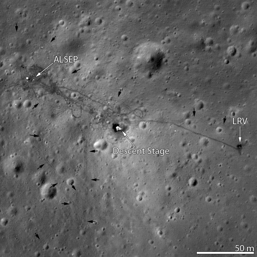
Hardware, rover tracks, and astronaut paths from orbit
Descent stages, experiment packages, and—on later missions—rovers leave signatures that match engineering scale, illumination geometry, and what surface photography recorded during the flights.
High-resolution passes resolve the lunar modules’ descent stages, experiment packages, and—in later missions—rovers and wheel tracks. Astronaut paths appear as subtle darkening where regolith was disturbed.
The same sites also appear in Hasselblad photography from the surface. When those historical frames are compared to modern terrain models, boulders, slopes, and crater rims line up within expected uncertainty.
Why this matters
Hardware and tracks are falsifiable predictions: if coordinates or lighting were wrong, the shadows and footprints would not align across epochs.
Official & primary sources
- https://www.flickr.com/photos/gsfc/6816337786/
- https://www.lroc.asu.edu/featured_sites/view/apollo_15_visited
- https://www.lroc.asu.edu/posts/1135

Line of evidence
Apollo retroreflectors and lunar laser ranging (LLR)
Apollo 11, 14, and 15 each placed corner-cube arrays for Earth–Moon time-of-flight ranging. Observatories still detect returns from those sites today.
Observatories fire short laser pulses and detect a small return from the lunar arrays (and from Soviet Lunokhod reflectors). Range residuals feed lunar ephemerides, Earth orientation, and tests of gravity.
The arrays sit at published selenographic coordinates. Natural geology does not reproduce the same cube-corner signature, timing, and signal strength across fifty years of operation.
Why this matters
Laser ranging is quantitative and repeatable. It is an ongoing experiment, not a historical anecdote.
Official & primary sources
- https://science.nasa.gov/moon/lunar-laser-ranging/
- https://ilrs.gsfc.nasa.gov/
Line of evidence
NASA archives, surface journals, and mission documentation
Flight plans, debriefs, photo indexes, and telemetry archives preserve an internally consistent operational record that third parties can audit in public repositories.
Mission rules, real-time logs, and experiment PI documentation describe what was deployed where, and when. Surface journals align voice transcripts with Hasselblad magazine frames and traverse maps.
Third parties can audit many of these materials because they were archived in national libraries, data centers, and public repositories—not locked in a single narrative.
Why this matters
Forgery at this depth would require coordinated error across independent subsystems, contractors, and international partners. The simpler explanation is that the missions occurred as documented.
Official & primary sources
- https://www.nasa.gov/mission_pages/apollo/missions/index.html
- https://www.hq.nasa.gov/alsj/
- https://nssdc.gsfc.nasa.gov/nmc/spacecraft/search.action

Line of evidence
Why worldwide, decades-long checks matter
Universities, space agencies, and laser stations reprocess the same public LROC products and ranging data—not a single gatekeeper.
LROC products are archived for planetary science. Lunar laser ranging is performed from multiple countries. Sample research continues in curated laboratories with chain-of-custody from the Apollo return capsules.
No one institution “owns” the proof. That distribution of effort is exactly what makes large scientific claims robust.
Why this matters
When many teams can reprocess the same observations and get compatible results, confidence grows for the right reason: reproducibility, not rhetoric.
Official & primary sources
- https://lroc.sese.asu.edu/data
- https://curator.jsc.nasa.gov/lunar/
Questions readers often start with
Short answers only—each section above goes deeper, with primary links at the end of every block.
- Does the Lunar Reconnaissance Orbiter show the Apollo landing sites?
- Yes. LRO’s narrow-angle camera (LROC) has published georeferenced imagery over all six crewed landing zones. Featured-site pages and data releases show hardware, experiments, and regolith disturbance at the published coordinates. See Apollo landing sites from orbit for a single table with ASU featured links and mission dossiers, then the Evidence catalogue under “Orbital imagery” for additional catalogue rows.
- What is lunar laser ranging, and why does it matter for Apollo?
- Lunar laser ranging (LLR) measures the round-trip time of laser pulses from Earth to corner-cube arrays on the Moon. Apollo 11, 14, and 15 deployed arrays that remain in use; the signal characteristics and timing are not mimicked by ordinary lunar geology. NASA and ILRS publish program-level documentation.
- How do modern orbital photos relate to Apollo surface photography?
- Hasselblad panoramas and traverse maps from the missions can be compared to LRO terrain models and NAC frames. Boulders, slopes, and hardware positions should agree within expected uncertainty—another cross-check that does not depend on any single archive.
- Where should I go first for primary sources?
- Use the Sources index for institution-grouped portals (NASA, ASU/LROC, ILRS). The Evidence catalogue ties each type of proof to specific releases. Mission dossiers list mission-level NASA and LROC pages.
- Why emphasize “independent lines” of evidence?
- Because robust scientific claims survive when different methods agree. Orbital imaging, LLR, surface hardware visibility, and archival records each have different failure modes; convergence across them is the substantive reason for confidence—not rhetoric.
Continue from explanation to artefacts
The Evidence catalogue links each theme to primary releases. Explore places every landing in map context. Sources lists the main institutional portals for verification.